


Coasts
Erosional processes and features + hazards and management (focus on Mauritius or other location).
| 2.3 Coasts | |
| Candidates should be able to:Demonstrate an understanding of the work of the sea and wind in eroding, transporting and depositing Describe and explain the formation of the landforms associated with these processes Describe coral reefs and mangrove swamps and the conditions required for their development Demonstrate an understanding that coasts present hazards and offer opportunities for people Explain what can be done to manage the impacts of coastal erosion | Further GuidanceCliffs, wave-cut platforms, caves, arches, stacks, stumps, bay and headland coastlines, beaches, spits, and coastal sand dunes Hazards (including coastal erosion and tropical storms) |
| Case Study required for 1.5The opportunities presented by an area or areas of coastline, the associated hazards and their management | |
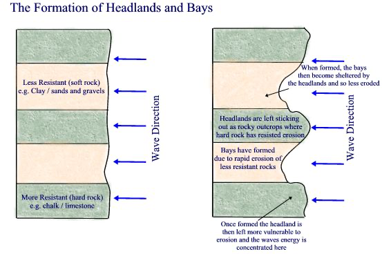
As you can see the image above showcases how waves erode the less resistant, soft rock which is mostly made of sand. The rate that it gets eroded at is much quicker compared to the rate at which the hard rock gets eroded. Because of this like the diagram showcases a bay is formed and is then protected by the headlands which are more resistant to the process of erosion.
Key Terms/Definitions
What is erosion?
Erosion is the geological process in which earthen materials are worn away and transported by natural forces such as wind or water. Most erosion is performed by liquid water, wind, or ice (usually in the form of a glacier). If the wind is dusty, or water or glacial ice is muddy, erosion is taking place.
What is Coastal Abrasion?
Abrasion is when rocks and other materials carried by the sea are picked up by strong waves and thrown against the coastline causing more material to be broken off and carried away by the sea.
What is Attrition?
Attrition is an erosional process. Rocks and pebbles are carried in the flow of a river. They repeatedly knock into each other, which causes the rocks to erode or to break. As the rocks continue to collide, they erode more and more, getting smaller and smaller until they are only sediment.
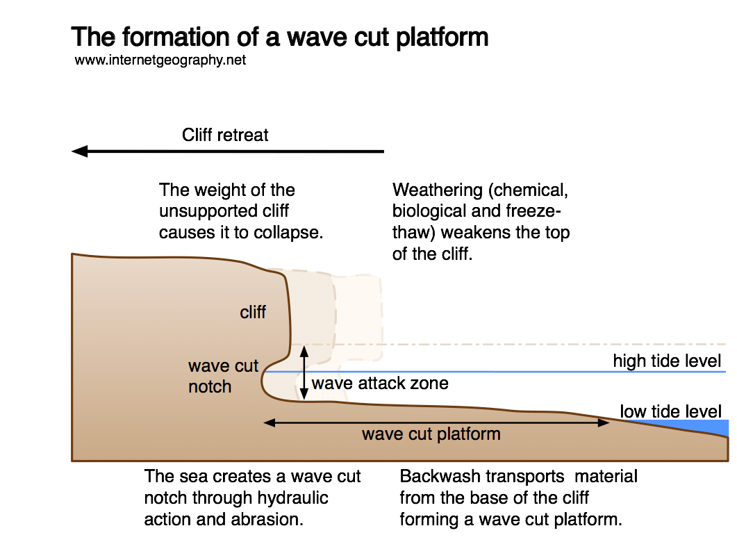
Wave-cut platforms form when destructive waves hit against the cliff face, causing an undercut between the high and low water marks, mainly as a result of abrasion, corrosion and hydraulic action, creating a wave-cut notch. When there is a high tide the waves are concentrated on a certain area on the cliff and this forms a notch, this again is due to the waves attacking a certain zone. This notch then expands and due to gravity the cliff above is not supported directly and collapses. The cliff then retreats and this created a wave cut platform.
The formation of a stump.
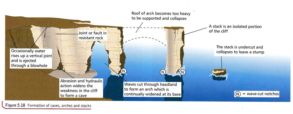
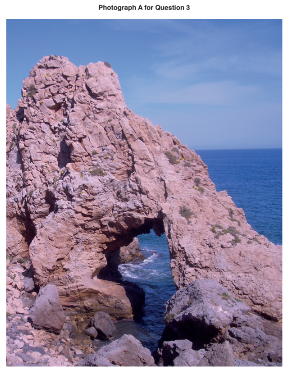
The formation of a stump happens due to a lot of hydraulic action and abrasion. First off there is a cliff and sue to a lot of hydraulic action and abrasion a crack is formed. Abrasion and further hydraulic action continues until this crack expands into a cave. This process of Abrasion and hydraulic action continuous to take place until an arch is formed but with no direct base to support it, the arch falls under the influence of gravity and leaves an isolated stack. More hydraulic action continuous to happen on the stack and eventually it gets reduced down to a stump.
Coral Reefs
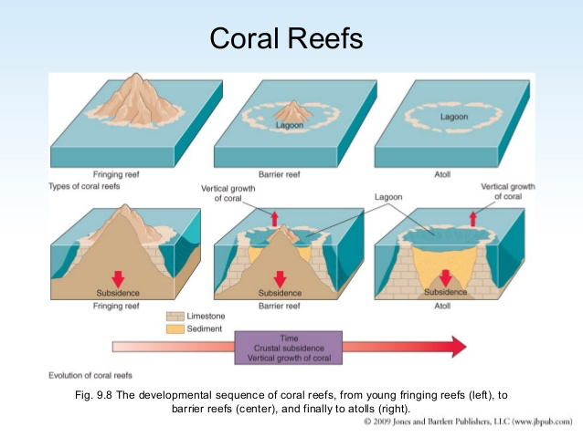
Types:
Fringing reefs grow near the coastline around islands and continents. They are separated from the shore by narrow, shallow lagoons. Fringing reefs are the most common type of reef that we see. Barrier reefs are also parallel the coastline but are separated by deeper, wider lagoons.
Atoll – These develop around island. Fringing reefs grow in a circle attached to the land. Sea-level rise or subsidence of the land causes the coral to grow at the height of the rising sea level to reach the light. This eventually forms a ring of coral reefs with a lagoon replacing the island in the centre.
Barrier reef – Coral grows in a shallower area away from the mainland. The water between is too deep for coral to grow and forms a lagoon. These reefs form offshore barriers along coastlines.
Conditions for growth:
- Warm Water the optimal is about 23-25 degrees celsius.
- Clear and shallow water is best for coral, no deeper than 50 meters.
- They need to be in shallow conditions to have access to sunlight to be able to aid photosynthesis.
- Coral needs to be grown in water containing sat as that is it’s natural environment.
- Water must be calm.
Mangrove swamps
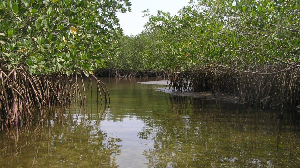
Mangrove trees are able to withstand being covered twice a day by saltwater. They have specially adapted aerial and salt filtering roots and salt excreting leaves that enable them to occupy the wetlands where other plants can’t survive.
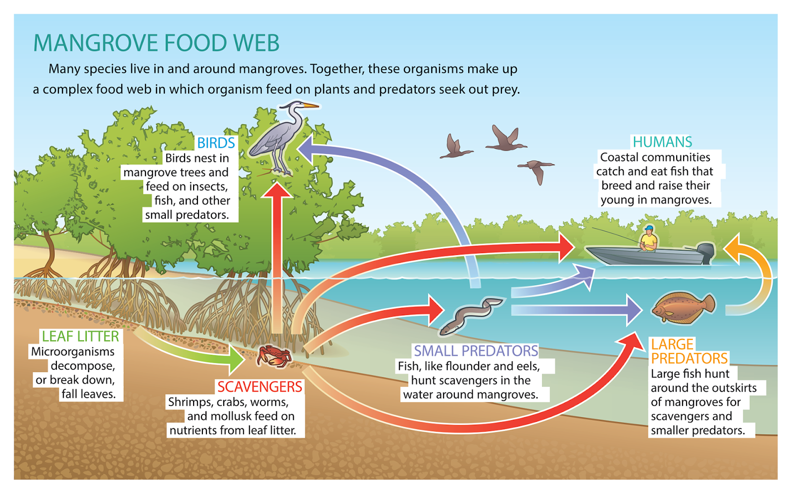
Mangrove swamps are home to a diverse number of species. Many species like crustaceans feed off the nutrients at the roots of the swamp and the swamp also offers them protection from predators and rough currents. The mangrove swamps filter out pollutants in the water leaving it clean for species to live here.
Conditions:
- Grow in sheltered tropical forests
- Between 32 degrees N and 38 degrees S
- They grow in salty waters
- They grow in areas where the temperature is around 20 degrees
- The temperature should not go below 5 degrees.
- Water should be calm
Mauritius
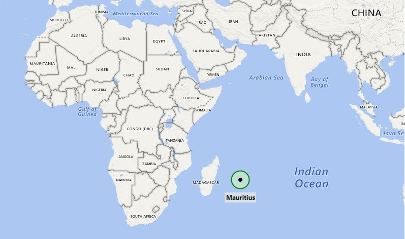
Mauritius is an island in the Indian Ocean which is famous for its beautiful lagoons and beaches. The coastline is 322 km long and is almost completely surrounded by fringing coral reefs.
Opportunities
The coastal zones and lagoons are used mainly for tourism, fishing and leisure activities such as diving, sailing and water skiing. Because of the increase in tourism there was also an increase in economic growth leading to the establishment of industries and financial services.
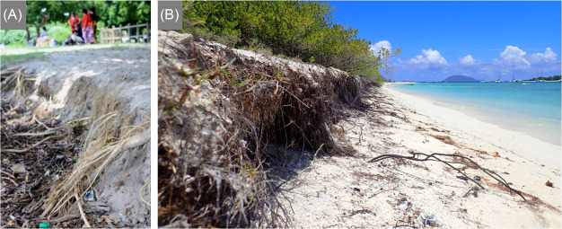
21 beaches in Mauritius experience coastal erosion and 22 sites have experienced coastal erosion, and the rate of it is still increasing. To use some examples, a survey showed that there has been erosion of 0.4 meters at Flic en Flac, 1 meter at Morne and 1.5 m at St Geran.
Solutions to these include soft and hard engineering.
Soft engineering
- Mangrove Swamps
Hard Engineering
- Groynes
- Seawalls
- Gabions
- Rip – Raps
- What are the optimal temperatures for coral growth?
- And what are the 3 types of reefs?
- Fringing, Barrier and Atoll
- Warm Water the optimal is about 23-25 degrees celsius.
- Clear and shallow water is best for coral, no deeper than 50 meters.
- They need to be in shallow conditions to have access to sunlight to be able to aid photosynthesis.
- Coral needs to be grown in water containing sat as that is it’s natural environment.
- Water must be calm.
Still got a question? Leave a comment
Leave a comment