


11.1 Changing Urban Environments
What is an Urban Environment?
An urban environment is a town or city with a high population density and a built-up area at the centre of a region.
There are two types of large cities with specific names:
- Millionaire cities have a population of over 1 million (in 1850, there were only 2 – London and Paris – but by 2002, there were 405!)
- Megacities (most of which are located on continental coastlines) have a population of over 8 – 10 million.
Urbanisation
Urbanisation is a process where an increasing proportion of people live in urban areas compared to rural areas.
Causes of Urbanisation
Urbanisation begins through rural-urban migration as a result of the following factors:
| Rural Push Factors | Urban Pull Factors |
| Mechanisation= Agricultural Unemployment | Industrialisation = Employment(MEDCs in 1750s / LEDCs in 1950s) |
| Lack of Services & Infrastructure | Better Services & Infrastructures(e.g. Schools, Hospitals etc.) |
| Rural Poverty | Urban Prosperity |
| Low Pay | Better Paid Jobs |
| Few Opportunities | Better Opportunities |
| Environmental Hazards (e.g. Drought, Flood) | Increased Quality of Life |
Many people who migrate to urban areas are young and therefore, urbanisation continues at a lower rate through natural population increase.
The Global Pattern of Urbanisation
Overall, developed countries (e.g. MEDCs) are the most urbanised but currently have a lower rate of urbanisation. In contrast, developing countries (e.g. LEDCs) are the least urbanised overall but currently have a higher rate of urbanisation. For example, between 1980 and 2010, 320 million more people moved to live in MEDC cities, whereas in LEDC cities this increase is closer to 2400 million.
MEDCs
MEDCs urbanised before LEDCs and therefore are more urbanised overall, despite a slower rate of urbanisation.
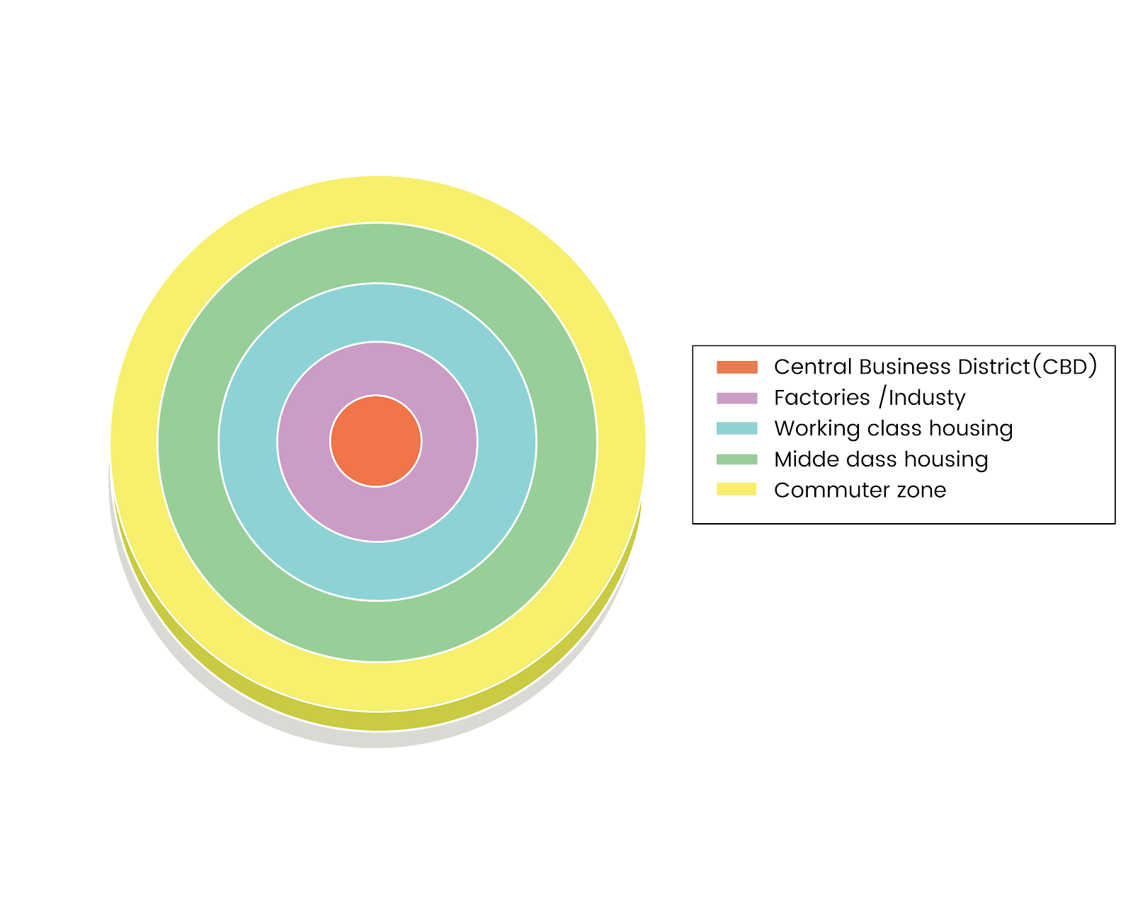
The Burgess Model shows the urban land use of MEDC cities:
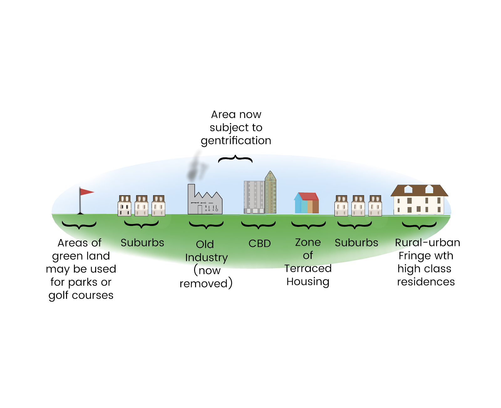
How MEDC cities developed is shown by the MEDC Urban Transect:
LEDCs
LEDCs urbanised after MEDCs and therefore are more urbanised overall, despite a slower rate of urbanisation.
This model shows the urban land use of LEDC cities:
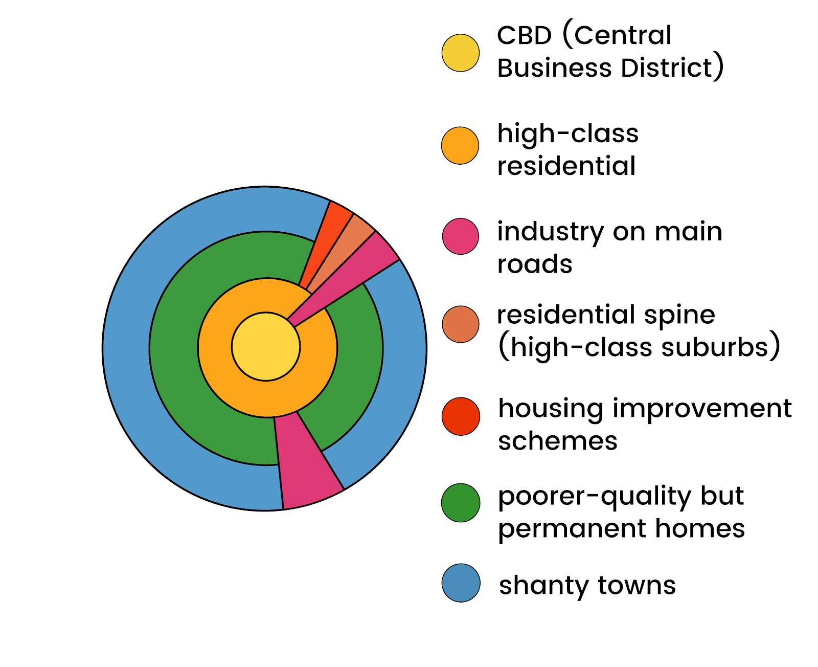
The urban morphology of LEDC cities tends to be the reverse of that in MEDC cities with the highest class residential areas being located closest to the CBD and then decreasing in quality as you move outwards towards the urban/rural fringe. This is in comparison to MEDC cities which have increasing residential quality as you move outwards towards the suburbs.
MEDC Urban Issues
CBD Decline
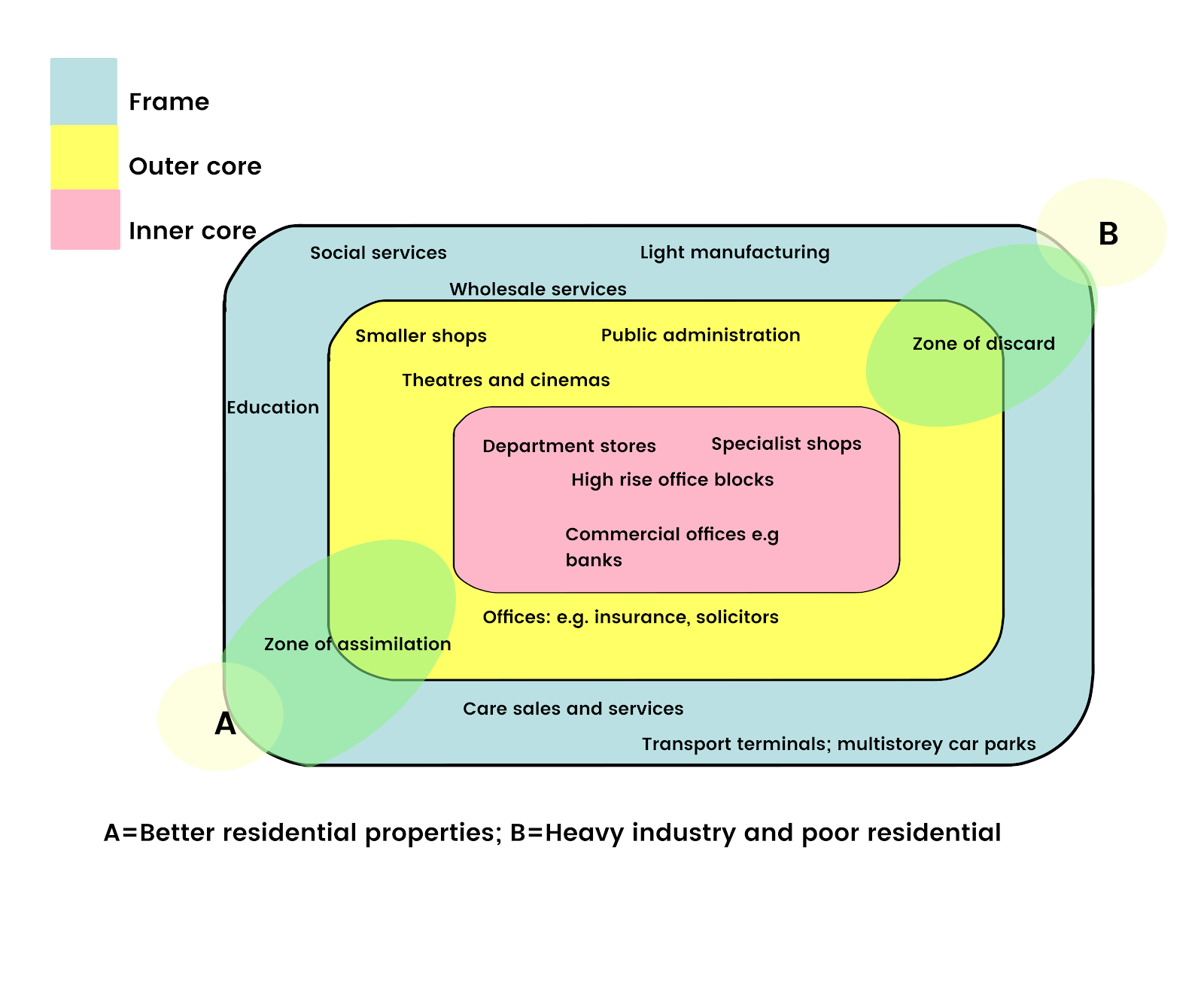
At the centre of a CBD, its core contains the largest department stores and has historically been the busiest part of the urban area. However, due to recent developments such as out of town shopping centres in conjunction with the recent recession, many of these stores have suffered and thus been outcompeted leading to some closing. As a result in some CBD’s you can find many empty and derelict buildings.
Due to deindustrialisation since the 1950s, cities which relied heavily on industry have seen job losses and the local economy suffer. Factory closures have also left the edge of the CBD (its Frame), and indeed also the Transition Zone, with many empty and derelict buildings. Buildings like this can make areas look unattractive and further exacerbate the problem. This can lead to the creation of a zone of discard.
CBD problems can be separated into 3 categories – social, economic and environmental:
- Social problems include noise and safety.
- Economic problems include shop closures, fewer shoppers and office space vacation.
- Environmental problems include litter, noise, air pollution and congestion.
In order to maintain the CBD’s quality and the local economy, councils have tried to improve the area in order to attract more shops and thus more businesses. Examples of strategies utilised include pedestrianisation, regular events, CBD reimaging (redevelopment to improve the appearance) and the creation of city centre indoor shopping centres to allow pleasant all year round shopping.
The diagram below shows the changing dynamic and land usage of the CBD:
Case Study: Warrington
The redevelopment of the Golden Square Shopping Centre located towards the edge of the CBD has attracted more shoppers and new shops, improved the appearance of this area and boosted the local economy; therefore a zone of assimilation has been created. However, it has attracted shoppers and thus shops away from the traditional CBD core and thus caused shops in these areas to move or close, creating a zone of discard.
Case Study: Birmingham
Birmingham relied heavily on manufacturing, and due to LEDC competition, factories closed down. Also, offices moved to smaller towns due to high congestion levels, and an out-of-town shopping centre opened in 1989, resulting in a 5% decrease in the city’s trade. Furthermore, the economy suffered, resulting in people having less money to spend in shops whilst the city centre shopping centre (known as ‘The Bullring’) was run down due to historic lack of investment. To improve the area: streets were pedestrianised, the New Street railway station had a £550m investment, traditional areas (e.g. the Jewellery Quarter) were reimaged, and empty factories/warehouses were redeveloped into apartments. However, the key project was to revitalise ‘The Bullring’ in a unique and aesthetically pleasing design (see left) well integrated into the rest of the city centre. These projects have improved the image of the area, decreased pollution and congestion, attracted new flagship stores such as Selfridges and revitalised the economy: now ‘The Bullring’ houses over 140 major stores and attracts more than 35m shoppers every year.
The Inner City Problem
In the past richer and higher-class workers moved away from the inner cities and into the suburbs / rural areas as transport improved and it became affordable. Therefore, the inner city has a poor and low-class population and the lowest quality housing.
The inner city problems can be separated into 3 categories – social, economic and environmental:
- Social problems include overcrowding, high levels of single parents/pensioners/students/ethnic minorities, below average health (and high levels of alcoholism and drug usage) and education levels and above average crime rates (and thus difficult police relations). There are also specifically political problems which include social unrest, rioting and extremism.
- Economic problems include declining industry, high levels of unemployment, high cost of land, low income, lack of capital investment and high proportions of low social classes.
- Environmental Issues (also known as Physical Issues) include housing stress, illness, slum conditions, lack of adequate open space, congestion, pollution, dereliction, poor facilities, run-down terraced housing, poorly built tower blocks and vandalism.
Due to these problems, planners, councils, and governments have utilised several strategies to reverse inner city decline. These are outlined below:
- Comprehensive Development Areas (1960s) – slums / terraced housing were knocked down and replaced with tower blocks which were badly built, overcrowded and rushed. Furthermore, the original buildings were knocked down too fast, resulting in homelessness. As a result, in most CDAs, further redevelopment has taken place.
Case Study: Hulme, Greater Manchester, UK
Here four ‘crescents’ were built which each housed 900 families.
- Urban Development Corporations & Enterprise Zones (1980s – 1990s) – property-led regeneration where UDCs were in charge of encouraging private sector investment to stimulate redevelopment and regeneration, whilst EZs were areas of land that offered incentives such as tax breaks, financial assistance and eased planning regulations so as to attract businesses.
Case Study: London Docklands Development Corporation (LDDC)
This was one of the first UDCs, operating between 1981 and 1988 in conjunction with the Isle of Dogs Enterprise Zone in Eastern London. Before the 1950s, it was the busiest port in the world, but by 1981, large container ships could no longer reach the port and containerisation had resulted in unemployment; therefore, there were few jobs, dereliction (50% of land) and lack of services/amenities/space and poor transport. The area is now known as Canary Wharf.
Social Regeneration:
- Over 22,000 new homes and 10,000 council houses refurbished.
- Population increased from 39,400 to 85,300.
- Now, 40% of homes are owner-occupied (compared to 5% previously).
- £100m spent on health, education, job training and community programmes.
Economic Regeneration:
- Improved Transport:
- New City Airport – 1/2 m passengers per year.
- Jubilee Line Extension (Tube) – 2000.
- 29km Docklands Light Railway – 350,000 people per week.
- 135km of new roads, including the M11 link.
- Employment increased from 27,000 to 71,000.
- Unemployment fell from 14.2% to 7.4%.
- The number of businesses increased from 1000 to 2400.
Environmental (Physical) Regeneration:
- 760 hectares of derelict land reclaimed.
- 2000 trees planted.
- 17 conservation areas set up.
- 150 hectares of open space created.
However, although yuppies gained employment, many local dock workers lost employment and if at all, could only get low-skilled jobs. Therefore the social demographic changed.
- City Challenge (1990s) – the areas where this operated suffered from high unemployment, low-skilled populations, low levels of educational attainment, dereliction, health problems, high crime rate and a high proportion of single-parent families. The aim was for local communities, companies, and the local council to work together to create a plan and then bid for governmental money to implement it. It aimed to tackle social, economic and environmental problems, whereas earlier solutions had only concentrated on improving buildings or the economy.
Case Study: Hulme City Challenge Partnership
This commenced in 1992 and received £37.8m from the government. It aimed to improve quality of life by building 3000 new homes with friendly and welcoming architecture (through the demolition of flats and in addition to 600 new homes for rent being built and 400 homes refurbished and improved), reclaiming 50ha derelict land by 1995, creating Hulme Park (Manchester’s first new large park for 60 years) and constructing a community centre with crèche (particularly important for mums with jobs).
- Education Action Zones (1998) aimed to improve underachieving schools’ performance to increase aspirations, prospects (through better qualifications) and eventually the standard of living due to better-paid jobs. Initially, 25 areas were made into these and such areas were given extra money to employ more teachers (= smaller class sizes), create summer/revision classes and implement student support programmes to tackle truancy, health, lateness and behavioural issues.
Case Study: Salford Education Action Zone, Manchester
Social Problems
Increased migration can lead to ethnic segregation (due to safety in numbers, specialist facilities, familiar culture, language barriers, employment factors, discrimination and support from others) that can damage Community Cohesion as a result of the creation of tension, friction, fear and mistrust due to lack of knowledge and understanding between different communities, primarily through the aforementioned segregation.
Case Study: Northern England Riots (Summer 2001)
- Oldham – Over 3 nights in May 2001, there was racial tension between the Asian and White Communities about social division, segregation between communities, poverty and racism. It resulted in 86 police officers being injured. Oldham is multi-cultural because of its history: in the 1950s there was a high demand for labour in cotton mills, and therefore immigration was encouraged through advertising in India; as a result, White and Asian areas of the city developed, leading to a lack of interaction, mistrust and deep-rooted segregation.
- Burnley – Rioting occurred next here and again White and Asian Communities clashed, but this time it was more youth and gang rivalry related, resulting in damage to property.
- Bradford – The worst violence was found here on 7th July 2001. In addition to other tension, there was a stand-off between the Anti-, League and the National Front which overall resulted in 1000 men destroying the Manningham area and 120 police officers being injured.
After these occurrences, the government launched an inquiry by Ted Cantle, who described that segregation meant different races living highly different lives. He recommended that we needed open and honest debate on the issues to foster ties, to introduce citizenship education within schools and for immigrants and finally, that no schools should be single faith (i.e. <75% one faith) within multi-cultural areas. The Commission on Integration and Cohesion was also established to tackle ethnic tensions with the slogan ‘fact, not myth’; the commission suggested twinning faith schools, encouraging neighbourly attitudes and that nobody should be denied opportunities from faith schools (especially Muslims from C of E schools).
One solution was ‘The Oldham Experiment’ where the >90% Asian Breeze Hill & >90% White Counthill Secondary Schools were gradually merged to become the Waterhead Academy under a new head teacher (David Yates, since resigned). It was originally over 2 campuses before becoming a single site with a new building in 2012. The merger began in September 2011 when signs, uniforms and head teacher were changed. Well-planned taster days at the neutral site began with small groups (e.g. drama days, taster days, football trials etc) before increasing in size before the full merger in September 2012 when it became a single site. This is a form of social engineering.
Transport Issues
The problem with transport in MEDCs is that it can cause pollution and smog, which contribute to Global Warming; as a result, excess transport usage can have a global-scale impact through the release of greenhouse gases such as carbon dioxide (CO2). Also, increased air pollution can decrease air quality (especially particulate pollution), which can increase the prevalence and severity of health issues such as asthma and bronchitis. Furthermore, the huge amount of vehicles on our roads can cause severe congestion, which can further increase pollution (and thus worsen the problems mentioned above), damage the economy through lost income due to late arrivals at work and meetings and adversely affect people’s health by causing stress brought on by poor punctuality. Finally, there is a major concern with the safety of our roads and the number of accidents that occur due to the sheer weight of traffic and carelessness.
There are several possible solutions to transport issues in MEDCs:
- Hybrid or Electric Cars
- Cycle to Work Schemes
- Traffic Calming (e.g. speed bumps, speed cameras and chicanes)
- Expensive Parking to discourage driving (particularly in the worst areas, e.g. CBDs)
- Park & Ride Schemes
- Improved Public Transport…
- Integrated Transport System
- Bi-Articulated Buses
- Buses With Increased Frequency and Reliability
- More Bus Lanes
- Improved Trains
- Underground & Tram Networks
Case Study: London, UK
Before 2003, over 40,000 vehicles drove in every morning and 50% of driving time was spent in queues. This congestion cost the local economy £2 – 4m per week, meaning that by 1998, average speeds during rush hour fell below 10mph.
On 17th February 2003, congestion charging was introduced where you had to pay a £5 charge to enter the charging zone (now £8 since 2005), which has been enforced through ANPR camera. You can pay via text, shops or internet and will be fined if you do not pay. Also, Transport for London is investing in improving the tube network whilst the city now has an integrated public transport system due to its large tube network connecting with major railway lines and its dense bus network in addition to the recent ‘Boris Bikes’ scheme.
By 2006, congestion had decreased by up to 30% (equivalent to the 1980s) with 50,000 (16%) fewer vehicles entering the charging zone. Now, 6% more people use buses and car journey times are 14% faster. There are 20% fewer accidents within the charging zone despite no significant traffic displacement outside this zone. There has been a 1% carbon dioxide (CO2) reduction and 14.9m litres of fuel saved. Finally, the charge raises approximately £100m annually, reinvesting in improving the public transport system.
Case Study: Birmingham, UK
To cope with its traffic issues, Birmingham has implemented Park and Ride schemes, has bus lanes (some have since been removed due to traffic flow restrictions) and encourages car sharing. The main project has been the construction of its own tramline, The Birmingham Metro, which runs for 20km (opened in 1999 at £145m).
The Housing Gap
As we gain more households due to an increasing population (> 7% since 1971) and social changes (e.g. increased divorce rates, rising life expectancy – ageing population, people staying single / marrying later = > 30% more households since 1971), we are facing a housing shortage where demand is higher than supply. This is exacerbated by the fact that not enough homes are being built, and when we are building, it is too fast and thus causing prices to fall dramatically; also, more homes are needed in the South, but there is more available derelict land in the North (thus creating another North-South Divide).
The solution is for the government to build 240,000 new houses annually until 2016 to stem the shortage and stop prices from spiralling out of control. 60% are to be built on Brownfield sites.
| Brownfield Land | Greenfield Land |
| Previously Used Land that is Derelict & Contaminated (Deindustrialisation) and is mostly located in Transition Zone & Northern England | New Land that has never been built on before (‘Virgin Land’), aka Countryside. |
| More Expensive to Build On | Cheaper to Build On |
| More Time Consuming to Build On | Quicker to Build On |
| Contaminated & Polluted Land | Lower Levels of Pollution |
| Higher Density Building | Lower Density Building |
| Less Desirable Locations | Desirable Locations in Urban – Rural Fringe |
| Gentrification – Yuppies move in | Suited to Families |
| Regeneration of Run Down Areas | Environmental Impact (e.g. Habitats, Cars) |
| Prevents Urban Sprawl & Donut | Can lead to Inner City & CBD Decline |
| Central Location (Shorter Journeys) | Isolated & Less Sustainable |
A Greenbelt of Greenfield land surrounds Towns and Cities in the UK to prevent the expansion of these to become Conurbations through Housing Developments in the Urban-Rural Fringe causing Urban Sprawl. If Urban Sprawl continues, it will cause migration, the death of town centres and the Urban Donut Effect.
LEDC Urban Issues – The Problems of Rapid Urbanisation
Rapid Urbanisation in LEDCs from the 1950s can create Mega Cities through Rural Urban Migration and Natural Population Increase. This often leads to several problems outlined below.
Environmental Problems
Despite lower levels of car ownership, traffic congestion is worse due to fewer road laws and competition with more traditional forms of transport such as animals (e.g. donkeys), bicycles, rickshaws and walking. This can create air pollution and toxic smog (e.g. Beijing) and thus health risks (e.g. for asthmatics and those with bronchitis and increasing the prevalence of lung cancer and tuberculosis). This is exacerbated by the use of low-grade leaded petrol. There can also be problems with water pollution due to open sewers and runoff from these. This can result in the contamination of food crops and localised extinction leading to decreased biodiversity within the local ecosystem. There can also be depletion in underground water stores, and sewage/waste can block rivers, thus increasing the risk of flooding. Finally, land pollution can be caused by the dumping of rubbish (which can clog up drains) and desertification caused by deforestation.
These problems can be managed by improving road networks and public transport to create an integrated transport network whilst also improving efficiency and the quality of petrol (e.g. switch to unleaded). Emission controls and fines could also be introduced, and enforcement improved. Finally, more council services could be provided (e.g. waste disposal, water pipes) but these are low priorities with limited money and time and an agenda for swift economic growth.
Economic Problems
There are often too few jobs for the ever-increasing population, and this can lead to poverty and an increase in the incidence of child and informal employment. There is also a high cost of living due to the high demand for land and goods. These can be improved by providing tax incentives that decrease prices and encourage the relocation of companies to the city, but ultimately the best solution to all problems would be to improve rural areas to prevent migration in the first place.
Social Problems
There can be a low level of education due to the need to work and limited healthcare (lack of birth control can worsen the issues by increasing the population even further). Also, there can be discrimination, tension, unrest, and overcrowding. Lack of available housing can lead to the development of shanty towns (see overleaf). These can lead to problems with disease which spreads easily and is highly prevalent. High-rise buildings could help ease overcrowding, and the growth of suburbs could deter migration. Furthermore the government could invest in providing facilities and services in addition to other solutions mentioned overleaf in the shanty towns section.
Case Study: Mexico City, Mexico
This is one of the fastest cities in the world with an estimated population of 16 million however, in reality, this could be twice as high! This is constantly rising due to tradition dictating the rejection of contraception and improvements in health care. There are many pull factors in addition to push factors, such as in rural areas 1/3 Mexicans lacking health care and 80% having no running water.
Problems
- Over 11,000 tonnes of rubbish are created every day, but only 75% is collected; this can clog up drains.
- Approximately 200 tonnes of untreated sewage is pumped into the main river per day which downstream is used to irrigate crops; this results in them having twice the lead level permitted in the USA.
- There are 3 million vehicles registered and this number increases every single day, thus causing severe pollution. 12,000 tonnes of pollution are released every day, creating a toxic smog equivalent to smoking 60 cigarettes per day. Due to the continued use of leaded petrol, 50% of newborns have very high levels of lead in their blood, which could impair mental and physical development.
- There are temporary shacks and squatter settlements anywhere and everywhere, with many in dangerous locations such as near polluted canal banks.
- 2/3 of the inhabitants in Valle Gomez (a squatter settlement on the edge of the city) have no access to health care or education; there is also a high teenage pregnancy rate.
- Cost of living is the same as in the USA even though workers earn much less.
- Most people work in the informal sector.
Solutions
- Improve housing through self-help schemes.
- The government have built an underground system and new ring roads.
- ‘Hoy No Circulan’ – one colour of car banned from roads each day but often wealthy residents by multiple cars of different colours.
- Investment in basic services such as transport, water and sewage in poor areas.
- New buses with unleaded fuel.
- Business tax breaks – attracted $1bn investment in the very centre of CBD.
Case Study: Mumbai (Bombay), India
Problems
- 60% of residents live in poverty, predominantly within Shanty Towns (e.g. Dharavi, see overleaf).
- The Mithi River is seriously polluted due to the dumping of industrial waste by industry, the dumping of untreated oil by the airport and the passage of 800m litres of untreated sewage per day into the river.
- Solid metal and plastic waste dumped into the Mithi River blocks drains, clogs it up and allows plant growth, thus increasing the risk of flooding. In July 2005, it flooded almost 25% of Mumbai after 1 metre of rain fell within 24 hours; this resulted in 406 deaths and a cost to the city of $100m.
- Large-scale air pollution due to large usage of fossil fuels due to high electricity demand, increased vehicle usage/congestion and the effect of industry.
Solutions
- Vision Mumbai (see Dharavi section overleaf).
- River Channel was dredged to increase depth, widened and obstacles removed; banks were smoothed near bends to allow easier flow to the sea.
- Checking of waste discharges into the river from factories.
- Construction of more public toilets to reduce raw sewage.
- New metro system due to open in 2011; nine lines planned by 2021 with 32.5km / 146.5km track underground.
- Banned the use of Diesel Fuel.
- All 58,000 taxis are now fuelled by natural gas, reducing greenhouse gases.
- Main roads upgraded, and 55 new flyovers to reduce congestion.
Case Study: Cairo, Egypt
The largest city in Africa with an official population of 11m but an estimated population of at least 16m faces problems which include traffic congestion and sewage. Although there are no shanty towns, informal houses cover 80% of Greater Cairo, predominantly on land reserved for food supply near the River Nile by the government. Also, urban sprawl has extended to the Great Pyramids and Sphinx whilst the population density is 33,000 people per km, with each person having a living space of less than 2m2 on average.
Solutions
- First metro system in Africa constructed with quick, comfortable, air-con trains – used by 2m commuters daily.
- Ring Road built around the city.
- The Greater Cairo Sewage Project – repair and extend the 1910-based system.
- Zabbaleen, with donkey carts, collect rubbish and recycling.
- 40 new settlements to house 15m people (e.g. 6th October City) constructed away from Cairo to attract people away from the city.
Shanty Towns
Shanty Towns, or Squatter Settlements, develop due to rapid rural-to-urban migration and are areas of illegal informal housing. They usually spread outwards from the CBD, with those on the edge being the newest and lowest quality, although this does improve over time. As migration is too fast to construct adequate formal housing, the residents build them using any materials they can find. Due to a lack of jobs in LEDC cities, residents usually work in the informal sector.
The typical characteristics of a shanty town are high levels of informal employment, constant expansion, build-up of landfill/rubbish anywhere and everywhere, poor quality and quantity of water, disease, high death rate, very high population density, a strong sense of community, poor environmental quality, poor sanitation and open sewerage.
The following strategies can be utilised to improve shanty towns:
- Eviction – forcing residents to leave and then demolishing the shanty town to deter people from returning.
- Redevelopment – the shanty town is demolished, with the residents usually being provided housing in the new scheme after completion but not during construction.
- ASH (Aided Self Help) – in self help schemes, the local authority supports the residents in improving their homes by helping them to learn skills and purchase materials.
- Site & Service Scheme – land is identified, and infrastructure (concrete base, water, sanitation and electricity) is laid before residents settle in the plot where they can then build and improve their home as they can afford to.
- NGO Support – charities work with local communities to provide infrastructure such as water pumps and toilet blocks (there may be a small but affordable fee to allow self-sufficiency and full sustainability).
Case Study: Dharavi, Mumbai (Bombay), India
This shanty town was visited by Kevin McCloud for a Channel 4 documentary – ‘Slumming It’ – and is thought to be Asia’s largest shanty town has been established on the eastern fringe of the CBD (between two railway lines) for about 100 years, covering an area of 1.8km2. An estimated 1m people live here, with a population density of 555,555 per km2 in 2004. Dharavi has a thriving pottery business at its centre, and 1 million single-room factories producing items such as suitcase handles.
Currently on hold since 2009 due to the global financial crisis, Vision Mumbai is a $1.3bn redevelopment scheme devised by Mukesh Mehta. It was expected to take 5-7 years and would involve rehousing pre-2000 residents in cramped tower blocks containing 1.1m higher quality but low cost 300m2 flats (cutting the number of slum dwellers by 90%) with the remaining land being used for malls, offices and upmarket apartments.
Case Study: Kibera, Nairobi, Kenya
60% of Nairobi’s population live in several shanty towns, with Kibera covering an area of 3.9km2 6.4km south of the capital city. There is an estimated population of 1m people, with each slum dweller having an average of just 1m3 of space! It is Kenya’s (and probably Africa’s) largest slum, with each standpipe and latrine catering for 50 shacks or 300 people; therefore, the ‘flying toilet’ is extremely common. The average shack measures just 3.6m x 3.6m and is constructed from tin, cardboard and plastic sheeting; as a result, they tend to lack structural integrity and weatherproofing.
In the 1960s, the city authorities tried to evict in shanty towns however, it didn’t work.
Since 1999, Christian Aid have worked with a local organisation (Maji na Ufansi, MNU) within the Matopeni area of the slum to install water and sanitation blocks which require a small fee for usage and have locals paid to maintain them. MNU has also lobbied for authorities to collect rubbish from a central point.
Case Study: Old Naredi, Gabarone, Botswana
By 1971, 6000 people lived here illegally on a 24ha site which lacked water, waste disposal, drainage and electricity. Therefore, in 1963 the city council wanted to bulldoze it however, this proved too expensive and instead, the settlement was made legal in 1975 and improved using the three-phase ‘Self Help Housing Association Scheme (SHHA):
- Basic Site & Service Provision – a land area marked out and basic services (unsurfaced roads, basic water supply, main drains) were provided before families being allocated plots where they could obtain cheap building materials and loans.
- Improved Site & Service Provision – schools, shops and community facilities were developed with water supply, drains and pathways improved; standpipes and rubbish collection points were installed for every five homes.
- Improvements Up To 2009 – local small business enterprises were established, and a few hours of electricity were provided to each home daily, which now all had their own standpipe and proper sanitation facilities.
Case Study: Paraisopolis (‘Paradise City’), São Paulo, Brazil
São Paolo is Brazil’s biggest city containing 18 million people, of whom at least 2.5 million live in shanty towns. In the 1990s, ASH schemes were introduced, including providing roads to link areas with the city’s transport network. Residents were provided with simple single-storey homes built from breeze blocks (a cheap material), a water tank and an indoor bathroom. Some families which have gained formal employment have since extended upwards to add a second story.
In Paraisopolis, many areas are now integrated into the city’s transport network and have piped water, electricity and schools. Now many have low-skilled jobs, a chain store has opened to sell furniture and electrical goods, and even a housing market!
Sustainable Urban Living
Unsustainable cities consume large quantities of resources (e.g. energy, water, food, raw materials) and produce enormous amounts of waste and pollution. They have problems with land usage, waste disposal and recycling and traffic congestion.
A sustainable urban area provides a high standard of living that will continue into the foreseeable future with limited adverse effects for the future. Strategies to improve the sustainability of urban areas include being carbon-neutral, providing trees for carbon-offsetting, providing open green spaces, using natural flood management techniques, constructing efficient buildings from recycled materials where possible on Brownfield as opposed to Greenfield land, conserving cultural/historical/environmental sites, using renewable and un-polluting forms of energy whilst minimising usage and having your power plant, providing a range of employment, community cohesion, recycling to conserve supplies, treating any released waste, supporting local business and using local produce, providing a high capacity and quality integrated transport system that is cheap for users encouraging walking and cycling through specialist routes and encouraging the use of pay as you drive car-share schemes with electric vehicles (+ charging points).
Case Study: Beddington Zero Energy Development (BedZED), Wallington, S London, UK
Although small scale, this is the largest carbon-neutral development within the UK and is built on reclaimed Brownfield land, consisting of almost 100 eco-friendly homes which opened in 2002. Its high-density living saves space and fosters community spirit.
Features
- Uses 45% less energy than a normal development.
- Homes face south to maximise energy output from solar panels and minimise heating usage (81% less, also due to 300mm insulation) whilst attached offices face north to minimise air-con usage and travel.
- On-site biomass plant for use when required = slight net surplus in energy.
- Each home uses 58% less water than the average home, and all buildings have rainwater harvesting and waste water recycling systems.
- There are safe green lanes to encourage walking and cycling, good public transport links (on bus route, near to rail/tram/tube), no parking spaces outside hoses, ‘ZEDcars’ pay as you drive sharing scheme and provision of electric charging points (annual car mileage has halved).
- All building materials were natural, recycled or reclaimed were possible.
- 60% recycling rate compared to 18% UK average and Gov. target of 50% by 2020.
Case Study: Curitiba, Brazil
This sustainable city is typical in size with a population of 2m. It was achieved as the dream of the former mayor, Jaime Lerner, under a military dictatorship within 72 hours to stop business/car owners from stopping it with injunction; despite initial objections, even businesses now accept the idea as beneficial.
Features
- One of the first cities to provide a recycling scheme in the 1980s.
- 2/3 recycling rate but no cost rise, separated into organic and inorganic.
- Second-hand Library and museum containing disposed of ‘gems’.
- Solution of the Parks – river banks turned into parks with trees to solve persistent flooding issues (+ excess water diverted into lakes) and stop areas becoming shanty towns (no shanty towns in the city).
- Disused factories turned into community facilities.
- Developers are allowed to build taller skyscrapers if they create green space or pay the city council to do so.
- Integrated Transport System
- Dedicated bus lanes in the centre of roads.
- Express routes, ring roads and local roads.
- Above-ground routes have been developed instead of a costly subway.
- Volvo has developed 25m long biarticulated (‘double bendy’ / three carriages with two joins) buses that carry more passengers per driver.
- A normal bus carries ≈ 1000 passengers per day → express lane ≈ 2000 → articulated bus ≈ 3000 → biarticulated bus ≈ 4000.
- Pay low bus fares (< 10% income) in advance at bus stops to increase efficiency (quicker boarding = less idling = less pollution & journey times cut by 1/3 overall).
- Bus companies paid by km, not number of passengers to ensure wide coverage and all routes are well serviced.
- The Green Exchange
- Agricultural overproducers are paid by the council to exchange (possibly with bus tickets) for waste food for collected and separated waste from the poor.
- Increases public transport usage.
- Stops need for expensive road widening schemes as trucks can’t fit down narrow squatter lanes.
- Helps 30,000 families and collected 300 tonnes of waste.
Glossary
Brownfield Land – an area of previously used and built-up land that is now unused, derelict and able to be built on again.
CBD (Central Business District) – urban zone located in the centre of cities where land usage is predominantly commercial; in MEDCs, it is bordered by the transition zone, which, historically, has had predominantly industrial land usage, but in some MEDC cities has now been redeveloped into residential areas.
Counterurbanisation – the opposite of urbanisation where an increasing proportion of people in a country live in rural areas as they move away from large urban areas.
Deindustrialisation – the closure or decline of industry, particularly in MEDCs, due to the movement of factories to LEDCs through globalisation and in increase in the importance of the service sector of economies.
Greenfield Land – an area of unused countryside that is able to be built on; a ‘green belt’ of this land surrounds UK cities to prevent urban sprawl and the formation of conurbations.
Industrialisation – the growth and increasing importance of the manufacturing industry to a previously agricultural economy (MEDCs = 1750s / LEDCs = 1950s); made possible due to mechanisation after the discovery of coal.
Informal Sector – illegal and unregistered employment and settlement where no taxes are paid; this is usually small scale.
Inner City – in MEDCs, this borders the CBD and transition zones and is where you will find the oldest settlements (often terraced houses).
Integrated Transport System – a planned system where public transport on different routes links with each other to provide a ‘door-to-door’ service that rivals car usage.
Mega City – huge settlements which contain over 10m inhabitants.
Millionaire City – large settlements which contain over 1m inhabitants.
Multicultural – people of different racial, religious and cultural backgrounds living together in cohesive communities.
Reurbanisation – the movement of people back into urban areas due to redevelopments and improvements, especially in the transition zone; therefore an increasing proportion of people in a country live in urban areas once again.
Rural to Urban Migration – the movement of people from rural areas (i.e. small-scale countryside settlements such as villages) to urban areas, usually to escape poverty and search for work during a period of industrialisation.
Segregation – where different cultures, races and/or religions live in different districts of urban areas, separate from other cultures, races and/or religions.
Shanty Towns – also known as squatter settlements or ‘slums’; informal settlements built illegally on trespassed land, usually found at the edge of LEDC cities.
Suburbanisation – an increasing proportion of people in a country living in the suburbs as they move away from the centre of urban areas; possibly due to improved transport.
Suburbs – residential areas between the inner city and urban-rural fringe in MEDCs as transport improved; the inner suburbs were predominantly built as semi-detached houses during the inter-war period whilst the outer suburbs were built as detached houses more recently.
Sustainability – the principle of meeting the current needs of people whilst also considering and removing any possible negative affects (especially environmental) for the future.
Urbanisation – an increase in the proportion of people in a country living in urban areas (e.g. towns and cities) compared to rural areas.
Urban Sprawl – where cities increase in size to form conurbations through developments in the urban-rural fringe and greenbelt; can lead to the ‘urban doughnut effect’.
Still got a question? Leave a comment
Leave a comment